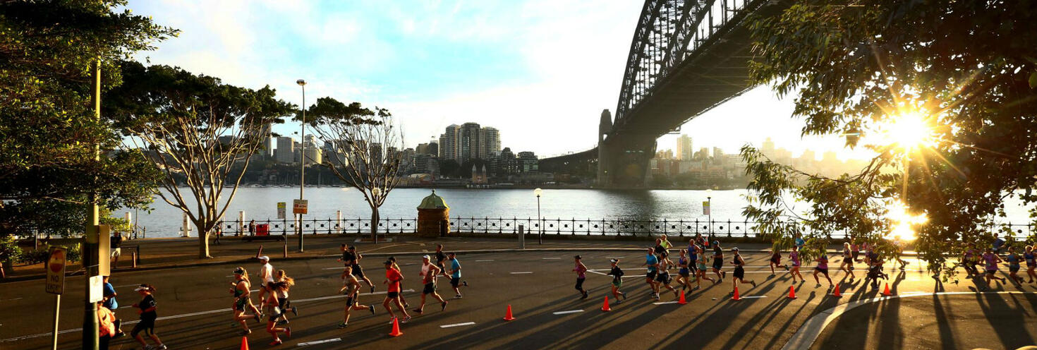
Runaway Sydney Half Marathon
Sydney CBD, Circular Quay, The Rocks & Pyrmont
-
10km event start
06:25
Half Marathon start 06:50
Events finish by 11:30
Important event information
More than 19,000 participants are expected to take part in the 21.1km Half Marathon and 10km courses for the Runaway Half Marathon event on Sunday morning.
Participants are encouraged to plan ahead and catch public transport as major roads will be closed along and surrounding the course from the early morning. See our Runaway Half Marathon 2024 Transport map (pdf 426KB) to find your way to the start line.
Transport
- Trains, buses and light rail services run regularly to the city to get you within walking distance of the course start area on the Cahill Expressway at Bridge St & Macquarie St near Circular Quay. See the course maps.
- Please note that due to planned weekend trackwork trains will not run to City Circle stations including Circular Quay which may affect how you travel to the start line.
- Trains from the West and South West will end at Central, and trains from the North Shore will end at Wynyard. T4 Eastern Suburbs & Illawarra Line trains will continue to run to Martin Place. Buses also replace some T2 Inner West Line trains, T3 Bankstown Line trains and Metro North West services on the weekend. Plan ahead using the Trip Planner.
- From Central, change for T4 Line trains to Martin Place or change for light rail services to Circular Quay to get within short walking distance of the start area. From Wynyard the start line is a short walk along Bridge St.
- Keep in mind that buses will be using different routes and stops while road closures are in place so plan ahead.
- Remember, you'll need to use an Opal card or contactless payment card/device when travelling on public transport to and from the event. Register your details online and plan your trip via the Opal Travel app.
Road closures
- Major roads in the Sydney CBD and Pyrmont will begin closing from 4am with roads progressively reopening between 9.30am and 2pm.
- Early-morning car parking is limited and access may be affected by road closures. Special event clearway parking restrictions will also be in effect on various roads, so check signage carefully as vehicles left in signposted clearway zones will be towed and a fee applies.
- For detailed road closure and clearway information visit livetraffic.com.
Stay connected
Keep informed on the day and get real-time updates on the event, public transport services and road closures:
- Event updates: follow Runaway Sydney Half Marathon on Facebook or @runawaysydneyhalf on Instagram for event information.
- Event course and start zone maps.
- Transport updates: follow @BusesInfo, @SydneyFerries, @TrainsInfo and @SydneyMetro
- See our Runaway Half Marathon 2024 Transport map (pdf 426KB)to find your way to the start line.
- Getting around is easy with the Opal Travel app. The Opal Travel app is the official Transport for NSW app to help you get around public transport. You can plan and save your trips, check your travel activities and fares, top up on the go and more. Download the FREE Opal Travel app now.
- Road closures and traffic conditions:
- Follow @LiveTrafficSyd on X (formerly Twitter) and Live Traffic NSW on Facebook for real-time updates
- For maps and detailed closure information visit livetraffic.com
- See our Transport for NSW interactive map or Runaway Half Marathon road closure and clearway map (pdf 1.9MB) for details.
Opal
You can use an Opal card for all modes of public transport in Sydney and surrounding regions, including metro, trains, buses, ferries and light rail.
Remember to top up your Opal card before you travel to avoid waiting in line at top-up machines. You can top up your card online or at an Opal retailer.
More ways to pay
If you have a contactless-enabled American Express, Mastercard or Visa debit or credit card, or a linked device, you can use it to pay for your travel by tapping on and tapping off at Opal card readers. Available on all public transport services including metro, trains, buses ferries and light rail, contactless payments are another way to pay on the Opal network. Adult Opal fare pricing applies and you will receive Opal benefits, including daily and weekly fare caps.
Sydney Metro services are high-frequency, driverless trains running between Tallawong Station and Chatswood Station.
Please note that due to planned weekend trackwork on Saturday 4 and Sunday 5 May, buses will replace all Metro services between Tallawong and Chatswood.
Catch a rail replacement bus to Chatswood to connect with trains to Wynyard to get within walking distance of the start area on the Cahill Expressway at Bridge St & Macquarie St near Circular Quay.
For Metro service disruption information, check travel alerts and trackwork or plan your trip using the Trip Planner.
The closest available stations to the start area on the Cahill Expressway at Bridge St & Macquarie St near Circular Quay are Wynyard and Martin Place. Due to planned weekend trackwork trains will not run to Circular Quay Station.
Trains start operating from the early morning, at around 4:40am depending on the train line.
Please note that due to planned weekend trackwork trains will not run to City Circle stations including Circular Quay which may affect how you travel to the start line. See our Runaway Half Marathon 2024 Transport map (pdf 426KB)to find your way to the start line.
- Trains from the West and South West will end at Central, and trains from the North Shore will end at Wynyard. T4 Eastern Suburbs & Illawarra Line trains will continue to run to Martin Place. Buses also replace some T2 Inner West Line trains, T3 Bankstown Line trains and Metro North West services on the weekend. Plan ahead using the Trip Planner.
- From Central, change T4 Line trains to Martin Place or light rail services to Circular Quay to get within short walking distance of the start area. From Wynyard the start line is a short walk along Bridge St.
Trackwork
Planned weekend trackwork is taking place on Sunday 5 May on the following lines and may affect how you travel to and from the event. Plan ahead using the Trip Planner.
- Metro North West Line: Buses replace metro between Tallawong and Chatswood.
- City Circle: Trains will not run on the City Circle, or between Central and Wynyard. For travel around the City use the light rail between Central and Circular Quay, or local bus services. T4 Eastern Suburbs Line trains continue to run between Central and Bondi Junction, stopping at Town Hall, Martin Place and Kings Cross. Trackwork also affects trains on other lines.
- T1 North Shore Line: Trains run to a changed timetable between Hornsby and Wynyard only. Trains will not run between Wynyard and Central, or on the City Circle. Change at Wynyard for the light rail or local buses to continue your journey. T9 Northern Line trains run to a changed timetable between Berowra and Central, platforms 1-12, via Strathfield. Buses also replace metro services between Chatswood and Tallawong.
- T1 Western Line: Trains run between Emu Plains and Central, platforms 1-12, and make extra stops at Flemington, Homebush and Burwood. Richmond trains run between Richmond and Leppington. Change trains at Parramatta to continue your journey towards Central. Trackwork on the City Circle may also affect how you travel. Change at Central for the light rail, or local buses to continue your journey. On Sunday from 5.30am to 10.20am, Richmond trains run between Richmond and Olympic Park.
- T2 Inner West & Leppington Line: Saturday from 8am, buses replace Inner West trains between Strathfield and Central. Express trains continue to run between Strathfield and Central, platforms 1-12. Trains run to a changed timetable between Leppington and Lidcombe via Regents Park, and between Leppington and Richmond. Change at Parramatta or Lidcombe for trains towards Central. T1 Western Line Penrith trains make extra stops at Flemington, Homebush and Burwood. On Sunday from 5.50am to 10.20am, buses replace trains between Cabramatta and Granville. Trackwork on the City Circle may also affect how you travel.
- T3 Bankstown Line: Buses replace trains between Lidcombe and Sydenham. Trains run between Liverpool and Lidcombe via Regents Park, and between Sydenham and Bondi Junction, to a changed timetable. Some T4 Illawarra Line trains make extra stops at St Peters and Erskineville. Trackwork on the City Circle may also affect how you travel.
- T4 Eastern Suburbs & Illawarra Line: All Cronulla and some Waterfall trains make extra stops at St Peters and Erskineville. Daily from 8am to 8pm, extra trains run between Hurstville and Bondi Junction. Trackwork on the City Circle may also affect how you travel.
- T5 Cumberland Line: Trains run to a changed timetable with extra trains running between Leppington and Richmond. On Sunday from 5.50am to 10.20am, buses replace trains between Cabramatta and Granville. Trains run to a changed timetable between Leppington and Lidcombe via Regents Park, and between Richmond or Schofields and Olympic Park. You may need to change trains at Lidcombe to continue your journey.
- T8 Airport & South Line: Trains run to a changed timetable and stopping pattern. You may need to change trains to continue your journey. Revesby trains run between Revesby and Central via the Airport. Most Macarthur trains run between Macarthur and Sydenham only. Change trains at Revesby if you are travelling to Airport stations. T4 Illawarra Line trains run between Sydenham and Bondi Junction.
- T9 Northern Line: Daily until 8am, trains run between Berowra and Central, platforms 1-12, to a reduced frequency every 30 minutes. Daily from 8am, trains run between Berowra or Hornsby and Central, platforms 1-12 only. Trackwork on the Metro North West and City Circle may also affect how you travel.
Trackwork is carried out on an ongoing basis to maintain the safety, reliability and efficiency of the Sydney Trains network. For the latest information, check travel alerts and trackwork or use the Trip Planner.
Plenty of buses make stops at Martin Place and Wynyard within short walking distance of the starting area on the Cahill Expressway at Bridge St & Macquarie St.
Keep in mind that buses will be affected by road closures for the event and will be diverting from their regular routes and using different stops. If you’re catching buses to and from the event, plan ahead to see if your route is affected.
For details on road closures see our Transport for NSW interactive map or Runaway Half Marathon road closure and clearway map (pdf 1.9MB).
Bus diversions
Buses to and from the city and Pyrmont will be diverting from their regular routes, terminating early and using different bus stops while road closures are in place for the event. Make sure to plan ahead and check your bus service using the Trip Planner
- Route 115, 202, 207, 208: From 4am to 11:30am services that usually run to and from Bridge St will instead start and end at York St Wynyard Stand P (Stop ID 200048). Services will pick up from Wynyard Park York St Stand K (Stop ID 200033). Stops on Bridge St will be missed in both directions.
- Routes 252, 288, 290 and 292: From 5am to 9:30am services will start and end their trips at Wynyard instead of King Street Wharf/Erskine St while closures are in place. Services will end trips at Wynyard York St Stand P (Stop ID 200048) and start from Clarence St Stand R near Margaret St (Stop ID 2000142). Stops on Erskine St and Sussex St will be missed.
- Route 263: From 4am to 11.30am, services will start and end trips at Wynyard. Services to the city will end trips at York St Stand P (Stop ID 200048). Services to Crows Nest will start trips from Wynyard Station, York St Stand L (Stop ID: 200034) instead of Bridge St. Stops on Bridge St will be missed in both directions.
- Route 304, 333, 343, 396 and 392N: From 4am to 9:30am buses that usually run to and from Circular Quay will start and end trips at Martin Place due to event closures on Phillip St. Services to the city will end trips at Martin Place Elizabeth St Stand C. Services leaving the city will start trips from Martin Place Elizabeth St Stand E (Stop ID 2000283). Continue on foot or change for light rail services to travel between Martin Place and Circular Quay during this time.
- Route 311, 324 and 325: From 4:30am until 11am services will start and end trips at Town Hall due to road closures. Services to Millers Point/Walsh Bay will end trips at Town Hall Park St Stand J (Stop ID 2000425). Services leaving the city will start trips from QVB, York St, Stand A (Stop ID 2000421).
- Route 389: From 5am to 10:30am services to Pyrmont will end at Miller St before Harris St (Stop ID 200932). Services towards Bondi will pick up from Harris St at Pyrmont Bridge Rd (Stop ID 200916). Services between Pyrmont and Bondi Junction will also be diverting around closures in the city via Pyrmont Bridge Rd, Western Distributor and Druitt St.
- Route 437: From 5am to 9:30am services to the city will divert via the Druitt St off-ramp and drop off at Market St Stand F (Stop ID 2000140). The stop on Sussex St after King St (Stop ID 2000228) will be missed. Services leaving the city will run as normal.
- Route 441 and 442: From 5am to 2pm services will start and end trips at QVB, York St Stand B (Stop ID 200042) due to closures on Art Gallery Rd and College St. All stops between QVB and The Domain will be missed. The stop on Sussex St will be missed between 5am and 9.30am only.
- Route 504 and 506: From 2am to 2pm services will start and end trips on Riley St due to closures in the Domain. Services to the Domain will end at Riley St opp Kennedy St (Stop ID 201157). Services leaving the city will start trips from Riley St at Cathedral St (Stop ID 201159). Stops on St Mary’s Rd will be missed.
For bus service disruption information, check travel alerts or plan your trip using the Trip Planner.
The closest wharf to the event start and finish line is Circular Quay however Sydney Ferries will operate to a regular Sunday timetable and services don't start running until later in the morning. Catch early morning buses or trains to get to the start line instead.
After the event you can catch a ferry home from Circular Quay which is approximately 20 minute’s walk from the finish line on College St at St Marys Cathedral.
Ferries can be busy particularly on Sundays, so have a back up transport option in mind. Use the Trip Planner to plan your trip home after the event.
For ferry service disruption information, check travel alerts or plan your trip using the Trip Planner.
L1 Dulwich Hill Line
L1 Dulwich Hill Line light rail services run between Central Station (Grand Concourse) and Dulwich Hill via Darling Harbour and the Inner West. Services run regularly from 5am to 1am daily. Plan your trip using the Trip Planner.
From Central change for L2/L3 light rail services to Circular Quay or Bridge Street stops to get within walking distance of the start line on the Cahill Expressway at Bridge St & Macquarie St.
L2 Randwick and L3 Kingsford Lines
L2 Randwick Line light rail services run between Circular Quay and Randwick via Central Station (Chalmers Street) and L3 Kingsford Line services run between Circular Quay and Juniors Kingsford via Central Station (Chalmers Street). Services run regularly from 5am to 1am daily, plan your trip using Trip Planner.
Catch L2 and L3 light rail services to Circular Quay or Bridge Street stops to get within walking distance of the start line on the Cahill Expressway at Bridge St & Macquarie St.
Additional L2 and L3 light rail services will run from 7am to 7pm due to Sydney Trains City Circle trackwork.
See our Runaway Half Marathon 2024 Transport map (pdf 426KB)to find your way to the start line.
For maps and service frequencies see light rail service information. For light rail service disruption information, check travel alerts or plan your trip using the Trip Planner.
Road closures
Major road closures will be in place on Sunday morning between 4am and 11:30am in the Sydney CBD, The Rocks, Dawes Point, Millers Point, Barangaroo, Pyrmont and Ultimo.
Motorists are encouraged to avoid non-essential travel in the CBD and Pyrmont areas during the event as delays are expected. Diversions will be in place, follow detour signs and allow extra travel time.
Access to properties within the road closure footprint will need to be done on foot with vehicle pick-ups and drop-offs to take place on the nearest available open road. Limited managed access will be permitted under traffic control for specific precincts when safe to do so. See details below.
Key closures:
- Sydney CBD - 2am to 2pm: Macquarie St between Hunter St and St James Rd, College St between Park St and Prince Albert Rd, St James Rd and Prince Albert Rd at Hyde Park (event finish line).
- Macquarie St will reopen southbound only from Hunter St to St James Rd/Elizabeth St at 12.30pm.
- Sydney CBD - 4am to 11.30am: Cahill Expressway Circular Quay Overpass, Macquarie St between Albert St and Bent St, Bridge St between Phillip St and Macquarie St, Conservatorium Rd and Kent St northbound from Margaret St to Argyle St.
- Motorists travelling toward the Eastern Distributor or the eastern suburbs should use the Sydney Harbour Tunnel while the Cahill Expressway Overpass is closed.
- Motorists can cross Macquarie St at Shakespeare Place & Bent St before 5.30am and after 11am. After 11am no access to or from Macquarie St. Access to the Eastern Distributor will be available via William St.
- Circular Quay - 4am to 9:30am: Bridge St from Phillip St to Young St, Bridge St eastbound from Pitt St to Phillip St, Phillip St (South of Bridge St) and Phillip Lane.
- Pyrmont & King St Wharf - 5am to 9:30am: the Western Distributor from Pyrmont to the CBD including Fig St, Pyrmont St and Market St on-ramps and King St and Harris off-ramps will be closed. Sections of Union St, Murray St, Pyrmont St, Darling Drive and surrounding local roads, Sussex St from Napoleon St to King St and Erskine St between Shelley St and Kent St will also be closed.
- Motorists travelling citybound on the Anzac Bridge will be detoured via the Bathurst Street off-ramp to rejoin the Harbour Bridge, no direct access from the Anzac Bridge to the Sydney Harbour Bridge. Motorists in Pyrmont travelling to the city, or the Harbour Bridge will be diverted via Harris St and local roads.
- Pyrmont - 5am to 10am: Pirrama Rd from Harris St to Darling Island Rd, Bowman St, Refinery Drive, Harris St and surrounding local roads.
- Pyrmont - 5am to 10:30am: Pirrama Rd between Darling Island Rd and Union St
- Millers Point & Barangaroo - 5am to 11am: Hickson Rd/Sussex St from Napoleon St to the Overseas Passenger Terminal, Towns Pl, Dalgety Rd, Pottinger St, Windmill St and Watson Rd.
- Access to the Rocks is maintained via York St, Lang St, and Harrington St.
- The Domain from 5am to 12pm: Hospital Rd, Art Gallery Rd, Mrs Macquaries Rd and St Marys Rd
Motorists are reminded that it is an offence to drive on or through a road closure point or exit a driveway onto a closed road unless directed otherwise by NSW Police or authorised personnel on-site. If you require access to your vehicle during the event you will need to relocate it outside the closure footprint prior to the road closures.
Maps
- Overview map - Runaway Half Marathon road closure and clearway map (pdf 1.9MB).
- Sydney CBD / Hyde Park area local access map (pdf 464KB)
- Pyrmont local access map (pdf 399KB)
- King St Wharf , Barangaroo and The Rocks local access map (pdf 1.1MB)
For details on road closure locations and times as well as real-time traffic updates, visit Live Traffic NSW or download a real-time traffic app.
Local access changes
Circular Quay
- Access will be managed under traffic control to properties on Albert St, Macquarie St (North of Albert St) and Phillip Lane throughout the closures for local residents/hotel guests only. Entry via Bridge St and Loftus St. Exit via Young St and Bridge St
- Access for local residents and hotel guests on Pitt St only will be maintained via Bridge St eastbound and Loftus St.
Sydney Hospital & Hospital Rd
- From 5am to 12pm: Two-way access to Hospital Rd via Shakespeare Place only under traffic control. No access from St Marys Rd
King St Wharf and Barangaroo South
- Access to and from King St Wharf, Cockle Bay Wharf and Barangaroo will be restricted to tenants/residents only and managed via Wheat Rd under traffic control between 6am and 9.30am. No access via Erskine St or Sussex St.
- Entry: via Harbour St continue Western Distributor northbound veer left into Wheat Rd at the signposted exit for Erskine St / CBD North
- Exit: Light vehicles will be able to exit the precinct via Wheat Rd southbound under two-way traffic control. Vehicles over 7 metres (including trucks, buses and coaches) will be unable to use the managed exit and will need to remain within the precinct until Erskine St reopens at 9.30am.
- Before and after these times access is maintained via Erskine St at Kent St. We strongly advise motorists to avoid non-essential travel to or from these precincts between 6am and 9.30am as delays are expected.
Millers Point & Barangaroo North
- Managed access for Kent St properties as far north as Argyle St and High St will be maintained by traffic control at the Margaret St intersection for the duration of the event. Kent St southbound exit allowed for local traffic only.
- From 9am to 11am only, access to Barangaroo Reserve & car park, Dalgety Rd and Bettington St will be available, entry via Kent St, High St, Argyle Pl, and Dalgety Rd.
The Rocks & Dawes Point local access:
- Maintained via Lang St & Harrington St throughout the event.
Pyrmont
- Murray St properties between Union St and Pyrmont St, and Wilson Parking 100 Murray St:
- between 5am and 9.30am access to and from properties/hotels on Murray St and surrounding local roads will be permitted under traffic control via Darling Drive for light vehicles and coaches only (trucks not permitted). Note, coaches can only turn around via hotel driveways.
- The Star: between 5am and 9.30am access to and from The Star car park is via Pyrmont St only
- Refinery Dr: Refinery Dr will be closed from 5am to 10am with exit permitted via Tambua St before 6:15am and after 9:15am only at Police discretion when there are safe gaps between runners. If you need access to your vehicle/property during these times, please plan ahead and relocate your vehicle prior.
- Pyrmont St properties between Bunn St and Murray St: exit from driveways permitted throughout event under traffic control.
- Wharf 7 and 10: From 5am to 10.30am, no access from/to Pirrama Rd from Wharf 7 and Wharf 10 access roads
Cycleway closures
- College St between Park St and St Marys Rd – 2am to 2pm
- King St between Phillip St Sth and Macquarie St - 5am to 11:30am
- No access to Macquarie St from King St Cycleway
- King St between Kent St and Sussex St – 5am to 9:30am
- Union St between Edward St and Murray St - 5am to 9:30am
Cyclist detours from 6am-11am Sydney Harbour Bridge: Cycling detours will be in place between Kent St cycleway and the Sydney Harbour Bridge cycleway, via Observatory Hill. Marshals will be on site to direct cyclists across Upper Fort St in both directions when safe gaps between runners are available. Alternatively, cyclists can travel between Sydney Harbour Bridge cycleway and Sydney CBD via Cumberland St.
For details on road closure locations and times as well as real-time traffic updates, visit Live Traffic NSW or download a real-time traffic app.
Parking
Limited parking is available at the following locations within walking distance of the start line on Bridge St at Macquarie St.
- Domain Car Park, – St Mary’s Road Sydney – Open 24hrs – $12 flat fee
- Enacon Car Park – Cathedral Street – Open 4:45am - $15 flat fee
Visit Wilson Parking or Secure Parking websites for other nearby car park options. Be mindful of car park opening times and road closures.
Special event clearways
Special event clearway parking restrictions will be in effect on various roads throughout the Sydney CBD, Circular Quay, The Rocks, Millers Point and Pyrmont between 12.01am and 12pm on Sunday 5 May for the event. For details on road closures see our Transport for NSW interactive map or Runaway Half Marathon road closure and clearway map (pdf 1.9MB).
-
- From 12.01am to 2pm: Macquarie St between Bent St and St James Rd, College St between Prince Albert Rd and Park St (Eastern side), St James Rd and Prince Albert Rd.
- From 1am to 9.30am: roads in Circular Quay including sections of Albert St, Bent St, Bligh St, Bridge St, Conservatorium Rd, Hunter St, Loftus St, Macquarie St, O’Connell St, Phillip St and Pitt St.
- From 2am to 9.30am:
- Pyrmont on roads including sections of Bowman St, Pirrama Rd, Harris St, Darling Island Rd, Jones Bay Rd, Wharf Cr, Murray St, Bunn St, Union St, Pyrmont St
- Sydney CBD west, Millers Point and Dawes Point on roads including Sussex St, Erskine St, Hickson Rd, Argyle St, Dalgety Rd, Pottinger St, Towns Pl, Upper Fort St, Watson Rd and Windmill St.
- The Domain: Art Gallery Rd, Mrs Macquaries Rd, Hospital Rd, Shakespeare Place and St Marys Rd.
- From 4am to 12pm: roads in the Sydney CBD including sections of Bathurst St, Castlereagh St, Grosvenor St, Kent St, Park St, Pitt St and York St.
These clearways are strict no parking zones even for local residents and Mobility Scheme Parking Permit holders.
Check signs carefully before parking on the day, and the night before as clearways come into effect from early morning on Sunday. Vehicles left in clearways will be towed and a fee applies. If your vehicle is towed it will be moved to the nearest available parking space, you can search your vehicle registration at the Find My Car website to find its new location, or alternatively call 132 701 to speak to an operator.
Maps
- Overview map - Runaway Half Marathon road closure and clearway map (pdf 1.9MB).
- Sydney CBD / Hyde Park area local access map (pdf 464KB)
- Pyrmont local access map (pdf 399KB)
- King St Wharf , Barangaroo and The Rocks local access map (pdf 1.1MB)
For details on clearway locations and times as well as real-time traffic updates, visit Live Traffic NSW or download a real-time traffic app.
Accessible trips are shown in the Trip Planner with the wheelchair icon. You can select "accessible services only" in the Options to ensure you only see accessible services. Only trip plans with accessible train platforms, ferry wharves and buses will be presented. See accessible travel or download a transport app (select the "Accessibility" filter).