1. Homechevron-right
  2. Planchevron-right
  3. chevron-leftInstructions and planning guideschevron-right
  4. Using Departures

Using Departures

View upcoming services leaving from a stop, station or wharf in real-time.


On this page

  • About departures
  • How to use it
  • What you'll see
  • Tips and features
  • View your service on the map
  • See also

On this page

  • About departures
  • How to use it
  • What you'll see
  • Tips and features
  • View your service on the map
  • See also

On this page

  • About departures
  • How to use it
  • What you'll see
  • Tips and features
  • View your service on the map
  • See also

On this page

  • About departures
  • How to use it
  • What you'll see
  • Tips and features
  • View your service on the map
  • See also
about_departures

About departures

how_to_use_it

How to use it

Follow these steps to check departures from a stop.

optional_actions

Optional actions

what_you_ll_see

What you'll see

tips_and_features

Tips and features

view_your_service_on_the_map

View your service on the map

see_also

See also

Connect with us

  • facebook icon
  • instagram icon
  • twitter icon
  • youtube icon

Transport pays respect to Elders past and present, and recognises and celebrates the diversity of Aboriginal peoples and their ongoing cultures and connections to the lands and waters of NSW.

© Transport for NSW

Departures shows upcoming services leaving from a stop, station or wharf in real-time.

It’s a quick way to check what’s leaving from a single location, without planning a full trip.

If you want to see services between two places, you can add a second stop on the same route or line.

1
Search for a stop

Enter the stop name or Stop ID in the search box. 

2
View live departures

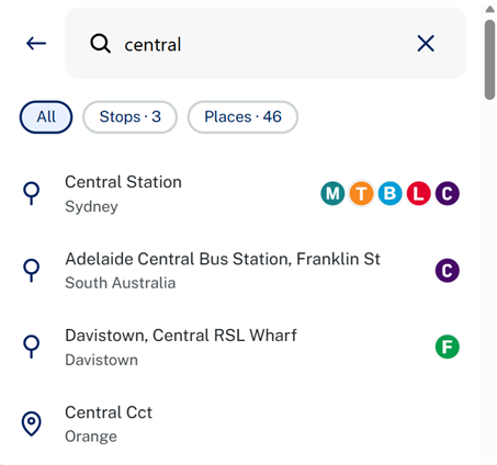
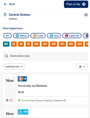
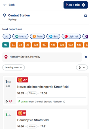
See real-time departure information for all services at that stop.

You’ll see:

  • Up-to-date departure times
  • Service and route details

Once you’ve found your stop and viewed departures, you can take additional actions to refine or extend your search.


1
Filter by modes or routes

Use filters to narrow results by transport mode or specific routes.

2
Add a destination

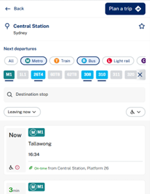
Add a second stop on the same route or line.

This lets you see services running between the two stops, which can help refine your results.

3
Open in Trip Planner

Select Plan a trip on a result to open it in the Trip Planner.

From there, you can:
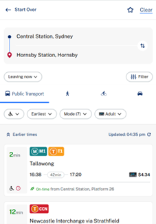
  • Compare alternative routes
  • Change travel times
  • Explore other journey options

Each card shows:

  • Departure time
  • Route number and direction
  • Real-time tracking (if available)
  • Accessibility and alert indicators

When you select a service, you’ll see:

  • All stops along the route
  • Travel alerts (if there are any active)
  • Accessibility indicators

Services are listed by earliest departure time, starting from now.

To change the time or day, select Leaving now and update your search.

  • Accessibility: A wheelchair icon marks accessible services. Use Filter to show accessible trips only.
  • Alerts: An alert icon shows if there are disruptions.
  • Real-time tracking: For many services, you’ll see the vehicle’s live location, route number and direction.
  • The first service in the list is shown on the map by default, with real-time tracking (if available).
  • Select a different result to update the map and see the location of that service instead.
  • How to use the Trip Planner
  • Plan your trip to school
  • Planning an accessible trip