Norton Street Italian Festa
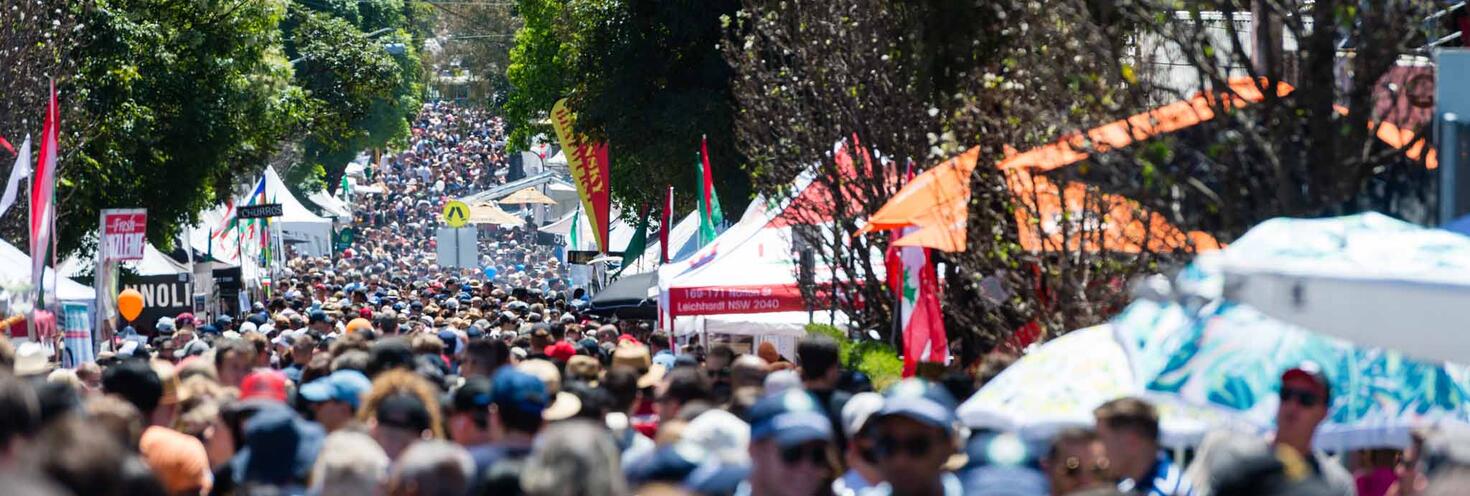
Norton St between Marion St and William St, Leichhardt
-
Start
10:00
Finish 17:00
Important Travel Advice
Up to 180,000 people are expected to visit the annual Italian Festa held on Norton Street between Marion Street and William Street in Leichhardt.
Visitors are encouraged to catch public transport and leave the car at home as roads will be closed. Traffic will be very heavy on roads approaching the event and on detour routes, and local parking is limited.
Transport
- L1 Light rail services run regularly to Marion and Leichhardt North stops which are both within walking distance of the festival. Regular route buses also run between the city and inner west stopping near Norton St. Note that some buses will be using different routes and stops nearby while roads are closed for the event.
- The closest station to Norton St Festa is Petersham however due to planned trackwork buses replace Inner West trains between Strathfield and Central during the event.
- Attendees will need to change for a replacement bus to Petersham or use alternative transport including light rail or local buses to get to the event. Plan ahead using the Trip Planner
Driving
- Road closures and special event clearway parking restrictions will be in place along Norton St and surrounding roads between 3am and 9pm. See our road closure map (pdf 399KB)
- If you have to drive, travel with your group and allow plenty of extra travel as delays are expected in the area. You can find real-time traffic conditions at livetraffic.com.
Opal
You can use an Opal card for all modes of public transport in Sydney and surrounding regions, including metro, trains, buses, ferries and light rail.
Remember to top up your Opal card before you travel to avoid waiting in line at top-up machines. You can top up your card online or at an Opal retailer.
More ways to pay
If you have a contactless-enabled American Express, Mastercard or Visa debit or credit card, or a linked device, you can use it to pay for your travel by tapping on and tapping off at Opal card readers. Available on all public transport, contactless payments are another way to pay on the Opal network. Adult Opal fare pricing applies and you will receive Opal benefits including daily and weekly fare caps.
Sydney Metro services are high-frequency, driverless trains running between Sydney’s north-west and south-west via the city.
The M1 Metro North West & Bankstown Line operates turn up-and-go Metro services between Tallawong, Chatswood and Sydenham from early morning until late.
Change at Central to connect with L1 Dulwich Hill Line light rail services to Marion or Leichhardt North, which is a short 10 minute (750m) walk away.
For Metro service disruption information, check trackwork and travel alerts or plan your trip using the Trip Planner.
The closest station to Norton St Festa is Petersham on the T2 Inner West Line, however due to planned trackwork buses replace Inner West trains between Strathfield and Central during the event.
Attendees will need to change for a replacement bus to Petersham or use alternative transport including light rail or local buses to get to the event. Plan ahead using the Trip Planner
From Petersham, Norton Street is about a 20-minute (1.5km) walk via Railway Street.
Trackwork
Planned trackwork is taking place on Sunday 25 October on the following lines and may affect how you travel to and from the event. Plan ahead using the Trip Planner:
- City Circle: Trains do not run on the City Circle, or between Central and Wynyard. For travel in the City use T4 Eastern Suburbs & Illawarra Line trains, metro, light rail, local buses or walk. Trackwork also affects trains on other lines
- T1 North Shore Line: Trains run to a changed timetable between Hornsby and Wynyard only, due to City Circle trackwork. Use metro services between Chatswood and the City or change at Wynyard for light rail or local bus services. Trains do not run between Wynyard and Central, or on the City Circle. From 7.30am to 8pm, buses replace trains between Hornsby and Gordon. Trains run to a changed timetable between Gordon and Wynyard only.
- T1 Western Line: Trains run to a changed timetable and stopping pattern between: Richmond and Liverpool. You may need to change trains at Parramatta to continue your journey; and Penrith and Central, platforms 1-14 only, making extra stops at Homebush, Flemington and Burwood. City Circle trackwork may also affect how you travel.
- T2 Leppington & Inner West Line: Buses replace Inner West trains between Strathfield and Central. Express trains continue to run. Trains run to a changed timetable between Leppington and Olympic Park via Granville. City Circle trackwork may also affect how you travel.
- T3 Liverpool & Inner West Line: Buses replace Inner West trains between Strathfield and Central. Express trains continue to run. Trains run to a changed timetable between Liverpool and Bankstown. Buses replace T6 Lidcombe & Bankstown Line trains between Bankstown and Lidcombe. City Circle trackwork may also affect how you travel.
- T4 Eastern Suburbs & Illawarra Line: All Cronulla and some Waterfall trains make extra stops at St Peters and Erskineville. Extra trains run between Hurstville and Bondi Junction. City Circle trackwork may also affect how you travel.
- T5 Cumberland Line: Trains run to a changed timetable and stopping pattern between Richmond and Liverpool, and between Schofields and Leppington.
- T6 Lidcombe & Bankstown Line: Buses replace trains between Bankstown and Lidcombe. Trains run between Liverpool and Bankstown, and between Lidcombe and the City.
- T7 Olympic Park Line: Trains run to a changed timetable and stopping pattern between Olympic Park and Lidcombe, with some trains continuing to Leppington.
- T8 Airport & South Line: Most trains run to a changed timetable between Macarthur and Sydenham, or between Revesby and Central via the Airport, due to City Circle trackwork. Change at Revesby for trains to Central via the Airport, or at Sydenham for metro services to the City and T4 Eastern Suburbs & Illawarra Line trains towards Bondi Junction. Early morning and late-night trains run between Macarthur and Central via the Airport. T8 trains do not run between Sydenham and the City. T4 Eastern Suburbs & Illawarra Line trains run between Sydenham and Bondi Junction, making extra stops at St Peters and Erskineville. City Circle trackwork may also affect how you travel.
- T9 Northern Line: Trains run to a changed timetable and stopping pattern between Berowra and Central, platforms 1-14, and between Hornsby and Epping. Use metro services between Epping and the City. City Circle trackwork may also affect how you travel.
- Blue Mountains Line: Trains may run to a changed timetable due to trackwork between Strathfield and Central. Trackwork on the City Circle may also affect how you travel. From 12.40am to 6am, most trains run between Blue Mountain Line stations and Blacktown only due to trackwork between Olympic Park and Central. Change at Blacktown to continue your journey.
- Central Coast & Newcastle Line: Trains may run to a changed timetable due to trackwork between Strathfield and Central. Trackwork on the City Circle may also affect how you travel. From 12.40am to 5am, buses replace all trains between Strathfield and Central. Trains run to a changed timetable between Central Coast & Newcastle Line stations and Strathfield only. Use metro services between Epping and the City.
- South Coast Line: Trains run to a changed timetable between South Coast Line stations and Sydenham only. Change at Sydenham for T4 Eastern Suburbs & Illawarra Line trains or metro services to continue your journey. City Circle trackwork may also affect how you travel.
Trackwork is carried out on an ongoing basis to maintain the safety, reliability, and efficiency of the Sydney Trains network. For train service disruption information, check trackwork and travel alerts or plan your trip using the Trip Planner.
Regular route buses
A number of buses run to and from Leichhardt and stop within walking distance of Norton Street or Marion Street. Some services will be diverting while roads are closed for the event so plan ahead using the Trip Planner.
Bus Diversions
From 3am until 9pm on Sunday 25 October, Route 437, 440 and 445 bus services will be diverting via Marion Street, Flood Street and William Street. Stops on Norton Street and Allen Street will be closed. Services will use temporary stops on William Street at Norton Street (Stop ID 2040117) and on William Street at James Street (Stop ID 2040118) instead.
For bus service disruption information, check travel alerts or plan your trip using the Trip Planner.
Catch one of the many ferry services to Circular Quay and for a train to Central. From Central, connect with an L1 Dulwich Hill Line light rail service to Leichardt North which is a short 10 minute (750m) walk away.
For ferry service disruption information, check travel alerts or plan your trip using the Trip Planner.
L1 Dulwich Hill Line
L1 Dulwich Hill line light rail services run between Central Station (Grand Concourse) and Dulwich Hill via Darling Harbour and the Inner West. Services run regularly from 5am to 1am daily. Plan your trip using the Trip Planner.
The closest light rail stop to Norton Street is Leichhardt North or Marion, which is a short walk away.
L2 Randwick and L3 Kingsford Lines
L2 Randwick Line light rail services run between Circular Quay and Randwick via Central Station (Chalmers Street) and L3 Kingsford Line services run between Circular Quay and Juniors Kingsford via Central Station (Chalmers Street). Services run regularly from 5am to 1am daily, plan your trip using the Trip Planner.
Change at Central Grand Concourse and connect with an L1 service to Leichhardt North or Marion to get within walking distance of Norton Street.
L4 Westmead and Carlingford Line
L4 Westmead and Carlingford Line light rail services run between Carlingford and Westmead via Parramatta CBD. Services run regularly from 5am to 1am daily, plan your trip using the Trip Planner.
Alight at Parramatta Square and connect with a train service to Central from Parramatta Station. From Central, connect with an L1 service to Leichhardt North to get within walking distance of Norton Street.
For maps and service frequencies see light rail service information. For light rail service disruption information, check travel alerts or plan your trip using the Trip Planner.
Road closures will be in place on Norton Street and surrounding local roads in Leichhardt for the festival.
Closures will affect both directions of traffic. Motorists should allow plenty of extra travel time as heavy traffic is expected on key roads approaching the area and detours will be in place. See our road closure map (pdf 399KB).
Road Closures
From 3am to 9pm
- Allen Street between Norton Street and Derbyshire Road
- Arthur Street between Allen Street and Short Street
- Norton Street between Marion Street and William Street
- Short Street between Norton Street and Derbyshire Road
- Wetherill Street* between Norton Street and Derbyshire Road
From 6am to 9pm
- Allen Street between James Street and Norton Street
- Carlisle Street between Cromwell Street and Norton Street
- Derbyshire Road from William Street
- Derbyshire Road between William Street and Moore Street West
- Lou Street between Allen Street and Marion Street
- Macauley Street* between Cromwell Street and Norton Street
- Marlborough Street between Cromwell Street and Norton Street
* Managed access only
For road closure details including maps and the latest traffic information visit Live Traffic NSW or download a real-time traffic app.
Parking
Attendees driving to the event are encouraged to arrive early and allow extra time for parking. Street parking is limited, and special event clearways will be in effect, check signs carefully before parking as vehicles left in clearways will be towed and a fee applies. See our road closure and clearways map (pdf 399KB).
Visit the Norton Street Italian Festa website for more details on car parks in the area. Consider the public transport options to get to the event and to avoid traffic delays.
Special Event Clearways
Special event clearways will be in place on both sides of the road at the following times and locations below, and see our road closure and clearway map (pdf 399KB).
From 3am to 9pm
- Norton Street between Marion Street and William Street
- William Street between James Street and Norton Street
Clearways are strict no-parking zones for all vehicle types and apply even to local residents and TfNSW Mobility Scheme Permit holders. Check signs carefully as vehicles left in clearways will be towed and a fee applies. If your vehicle is towed, you can search your vehicle registration at the Find My Car website to find its new location, or alternatively call 132 701 to speak to an operator.
Accessible trips are shown in the Trip Planner with the wheelchair icon. You can select "accessible services only" in the Options to ensure you only see accessible services. Only trip plans with accessible train platforms, ferry wharves and buses will be presented. See accessible travel or download a transport app (select the "Accessibility" filter).