City2Surf 2026
Hyde Park, Sydney CBD to Bondi Beach
-
City2Surf Expo at Hordern Pavilion from 6 to 8 August
.
Race starts near Hyde Park on William Street in the CBD
Event site opens at 6am
Runners released in waves from 7.35 am
Start line closes at 9.50 am
All runners finish at Bondi Beach by 2pm
Important event information
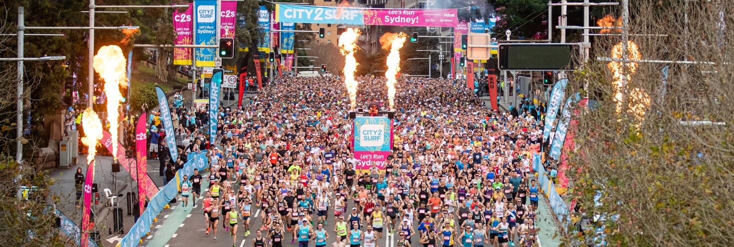
A sold-out group of 90,000 participants will take to the streets in the 56th annual City2Surf on Sunday 9 August. The 14km course is the world’s largest fun run, stretching from the Sydney CBD to the iconic Bondi Beach. The start line is located on Park St and College Street at Hyde Park. All runners will finish at Bondi Beach by 2pm. See course info for more details.
Transport
- Participants are encouraged to plan ahead and catch public transport as major roads will be closed along and surrounding the course from early morning, making driving and parking difficult. See detailed travel advice below and plan your trip using the Trip Planner or the free Opal Travel App.
- Travel on transport is included for participants and volunteers, simply show your race bib or pass to transport staff when boarding services.
- Extra trains, buses, metro, light rail and ferries will run. See the C2S start map (pdf 564KB) to find your way to the start line for your respective colour group:
- Red, Pink & Charity groups: Catch a train to Town Hall, St James or Museum; catch metro to Gadigal and exit via Park Street; use light rail or bus to QVB/Town Hall.
- Green & Blue groups: Catch a train to Town Hall or St James; catch metro to Martin Place; use light rail to Town Hall; or catch a bus to Elizabeth Street.
- Purple & Yellow groups: Catch a train to Town Hall or Museum; catch metro to Gadigal and exit via Bathurst Street; use light rail or bus to QVB/Town Hall.
- Orange group arriving before 8.30am: Catch a train or metro to Martin Place; use light rail to Wynyard; or catch a bus to Martin Place or Wynyard.
- Orange group arriving after 8.30am: Catch a train to Town Hall or St James; catch metro to Martin Place; use light rail to Town Hall; or catch a bus to Elizabeth Street.
- Frequent shuttle buses will run from Bondi Beach to Bondi Junction to connect you with trains to the city to help you get home again. Alternatively, consider the 35-minute (2.7km) walk to Bondi Junction to avoid queues for bus services.
- Buses between the city and Eastern Suburbs will have significant route diversions in place while roads are closed. Plan your trip ahead of time to see if your route is affected.
Road closures
- Roads around the start area at Hyde Park will close from as early as 3.30am. Major roads along the course from the city to Bondi will close from 6am. Roads will progressively reopen along the course from 11.30am with all roads reopened by 4pm.
- Special event clearway parking restrictions will be in effect from 1am along the entire course. Clearways in the city will lift from 12pm while those in the Eastern Suburbs will remain until 4pm. Check signage carefully as vehicles left in signposted clearway zones will be towed and a fee applies.
- For detailed road closure and clearway information visit livetraffic.com.
Stay connected
Keep informed on the day and get real-time updates on the event, public transport services and road closures:
- Event updates: follow City2Surf on Facebook and @City2Surf on Instagram.
- Event & Transport maps: Start and Finish maps, Start Access maps, Finish Area Transport Map (pdf 565KB)
- Transport updates: follow;@TrainsInfo, @BusesInfo, @FerriesInfo and @SydneyMetro.
- Road closures and traffic updates: follow @LiveTrafficNSW on X, Live Traffic NSW on Facebook and download the Live Traffic NSW app.
- Road closures and clearways maps: City2Surf road closures and clearways PDF map (pdf 5.9MB) or for our TfNSW Interactive Map.
City2Surf 2026 participants and volunteers are entitled to travel to and from the event on Sunday 9 August on the public transport services listed below. Just show your race bib, finishers medal or volunteer t-shirt to transport staff when boarding services.
- Sydney Trains and NSW TrainLink Intercity services (non-booked services bounded by Bomaderry, Goulburn, Bathurst, Scone and Dungog stations) *
- Sydney Metro services
- Sydney metropolitan and outer metropolitan buses
- Special event shuttle buses
- Sydney, Parramatta and Newcastle Light Rail services
- Sydney and Newcastle Ferries
Remember to keep your race bib, finishers medal or volunteer t-shirt safe for your return journey home, as these are also your ticket to travel on public transport or you'll need to use a valid Opal card/contactless payment method. Your entitlement is valid on public transport services until 4am the next day.
*Note: an additional train station access fee applies for travel to or from Domestic and International Airport stations and is not covered by 2025 City2Surf travel entitlements.
Transport Park&Ride Car Parks
Park for free when you catch public transport. Transport Park&Ride provides up to 18 hours of free parking each day. All you have to do is complete a public transport trip. Located close to public transport hubs, Park&Ride car parks help you connect more easily to train, bus and ferry services.
City2Surf 2026 participants and volunteers are entitled to travel on the abovementioned public transport services, which includes free Park&Ride parking. When leaving the car park use the intercom button at the exit gate to speak with the operator and show your event ticket.
If you use a Transport Connect account to access Park&Ride, the boom gate will automatically open as you leave the car park so you’ll need to request a refund in your account.
Real-time parking availability allows you to see how many vacant car park spaces are available at Transport Park&Ride car parks. For Park&Ride locations and more information on how it works, go to Transport Park&Ride.
City2Surf Expo
The City2Surf Expo will be held at the Hordern Pavilion in Moore Park from 6 to 8 August. The Hordern Pavilion is easily accessible by light rail and buses to Moore Park. All 2026 City2Surf participants must collect their race bib prior to the race on Sunday 9 August.
Expo opening hours:
- Thursday 6 August from : 12pm to 7pm
- Friday 7 August: 8am to 6:30pm
- Saturday 8 August: 7:30am to 4:30pm
Baggage drop-off is available during City2Surf Expo opening times. There is no race day bag drop available at the start line, and all bags must be collected from the event village at Bondi Beach by 2pm on Sunday 9 August. View the Pre-Event Info webpage for more details.
IMPORTANT NOTE – Saturday 8 August: the Moore Park precinct will be extremely busy across the day while other events take place at nearby venues, including when over 40k footy fans arrive from 2.15pm for an AFL match at the SCG. Significant traffic delays are expected, parking will be in high demand and transport services will be busy. City2Surf Expo attendees are encouraged to collect their race bibs prior to 2pm to avoid increased congestion and delays around the precinct.
Transport
Several transport services stop within short walking distance of Hordern Pavilion:
- Light Rail: services run regularly to Moore Park on the L2 Randwick and L3 Kingsford lines. The Moore Park stop is located along Anzac Parade, just south of the Hordern Pavilion.
- Trains and Metro: the closest train stations to the Moore Park precinct are Central and Bondi Junction, and the closest Metro station is Central. From Central, catch an L2 or L3 line light rail service from Chalmers Street to Moore Park on the L2 or L3 line. Alternatively, consider walking between Central and Moore Park via Devonshire Street and the Albert ‘Tibby’ Cotter Walkway. From Bondi Junction, catch one of the many regular route buses from the Interchange to Oxford Street.
- Buses: A number of regular route bus services stops along Anzac Parade near the Moore Park precinct, including routes 339, 373, 374 and 396. From Bondi Junction Interchange, routes 333, 352 or 440 stop on Oxford Street, or route 355 buses stop on Lang Road.
NOTE: Planned trackwork is taking place on the entire M1 Metro Line on Saturday 8 August from 4am to 9am. If you plan to travel by Metro before 9am, you will need to catch a replacement bus between Tallawong and Chatswood, and use Sydney Trains services between Epping or Chatswood, the City and Sydenham. For travel to and from Waterloo, you can use local buses or trains from Redfern. Plan ahead using the Trip Planner.
Parking
There are no drop-off locations around the Hordern Pavilion. Parking is available at the Entertainment Quarter Wilson Car park (casual parking rates apply), just 50m walk away. The car park is open 24 hours, entry is via Errol Flynn Boulevard from Lang Road.
IMPORTANT NOTE – Saturday 8 August: Due to special events in the Moore Park precinct, parking will be in high demand and a flat rate parking fee will apply after 1pm. Driver Avenue will be closed from 12.15pm and special event clearways on surrounding roads come into effect from 1pm. Plan accordingly.
Sydney Metro services are high-frequency, driverless trains running between Sydney’s north-west and south-west via the city.
The M1 Line operates turn up-and-go metro services in both directions between Tallawong, Chatswood and Sydenham. Services start from early morning and will run every 7-minutes from 6am to 4pm. Services will then run to a regular Sunday frequency for the rest of the day.
Getting to the start line
- Red, Pink & Charity groups: Alight at Gadigal and exit via Park Street.
- Green & Blue groups: Alight at Martin Place.
- Purple & Yellow groups: Alight at Gadigal and exit via Bathurst Street.
- Orange group: Alight at Martin Place.
- See the C2S start map (pdf 564KB) to help find your way.
Getting home from the finish line
- From Bondi Beach, catch an event shuttle bus to Bondi Junction to connect with a Sydney Trains service to Martin Place.
- From Martin Place, use the underground walkway to connect with Sydney Metro platforms for services towards Tallawong or Sydenham.
- Metro services will run every 7-minutes from 6am to 4pm.
For Metro service disruption information, check travel alerts and trackwork or plan your trip using the Trip Planner.
Getting to the start line
The closest stations to the start line on College Street at Hyde Park are Town Hall, St James, Museum and Martin Place.
Early-morning trains will start operating from 4am depending on the line, and regular services run to the city every 10-15 minutes on weekends. Additional services will leave Leppington at 5.58am and 6:28am – stopping at all stations Lidcombe via Regents Park, then Flemington, Strathfield, Burwood, Ashfield, Redfern, Central and then all stations to Circular Quay.
- Red, Pink & Charity groups: Alight at Town Hall, St James or Museum and continue towards Park Street.
- Green & Blue groups: Alight at Town Hall or St James and continue towards Hyde Park North.
- Purple & Yellow groups: Alight at Town Hall or Museum and continue towards Hyde Park South.
- Orange group: Alight at Martin Place and continue towards Macquarie Street.
- See the C2S start map (pdf 564KB) to help find your way.
Early-morning trains will start operating from 4am depending on the line, and regular services run to the city every 10-15 minutes on weekends.
Getting home from the finish line:
- From Bondi Beach, catch an event shuttle bus to Bondi Junction to connect with a Sydney Trains service to continue your trip home.
- At Bondi Junction, trains will run every 5-minutes from 10am to 4pm on the T4 Eastern Suburbs & Illawarra Line. Change at:
- Town Hall for T1 North Shore Line or T9 Norther Line services
- Central for T1 Western Line or Intercity services
- Redfern for T2 Leppington & Inner West Line services
- Lidcombe for T6 Bankstown Line service
- Wolli Creek for T8 Airport Line service
Trackwork
Planned trackwork is taking place on Sunday 9 August that may affect how you travel to and from the event. Plan ahead using the Trip Planner.
- T7 Olympic Park Line: Buses replace trains between Olympic Park and Lidcombe.
Trackwork is carried out on an ongoing basis to maintain the safety, reliability, and efficiency of the Sydney Trains network. Check travel alerts and trackwork or use the Trip Planner.
Getting to the start line
Plenty of buses make stops within short walking distance of the start area at Hyde Park. Plan your trip using the Trip Planner.
- Additional services will run on key routes to the city from 5am to help you reach the start line in time – from the Northern Beaches, Eastern Suburbs/Beaches, Inner West, North West, and Inner South.
- Route 382X from Bondi: buses will run from the temporary stop at Bondi Rd nr Sandridge (202654) to St James Station, Elizabeth St, Stand C (200057) every 10-minutes between 5.30am and 6am, then every 5-minutes until 8.30am.
- Route 333 from Bondi Beach: buses will run to Martin Place from the temporary stop at Sandridge St at Fletcher St (2026109) from 5.55am.
Keep in mind that buses will be affected by road closures and already diverting from their regular routes and using different stops when you are on your way to the start line. If you’re catching a bus to the event, plan ahead and see details of diversion below.
Getting home
- Event Shuttle Buses to Bondi Junction: services will run regularly from Campbell Parade to Bondi Junction between 9am and 4pm. Long queues are expected, particularly from 11am when large numbers of participants arrive at the finish line. Consider making the 35-minute (2.7km) walk to Bondi Junction if you can to avoid queues for services.
- From the Finish Village: use Queen Elizabeth Drive or the eastern footpath on Campbell Parade to access either bus stop.
- Accessibility: If you're travelling with a pram or have accessibility needs, catch a bus from the Lamrock Avenue stop to avoid the stairs. Ensure prams are folded down to allow faster boarding.
- At Bondi Junction: interchange to a train or another bus to continue your trip home.
- Route 333 to the city: buses will run to Circular Quay from the temporary stop at Sandridge St at Fletcher St (2026109) from 5.55am until 4pm.
- See the Finish Area Transport Map (pdf 565KB) to find your way.
Keep in mind that roads along the course may still be closed when you reach the finish line and some bus services will continue to divert from their regular routes until 4pm. If you’re catching a bus from the event, plan ahead and see details of diversion below.
For road closure details, see the City2Surf road closures and clearways map (pdf 5.9MB) or the TfNSW Interactive Map.
For bus service disruption information, check travel alerts for bus disruption information or plan your trip using the Trip Planner.
Bus diversions
Buses between the Sydney CBD and Eastern Suburbs will be significantly impacted by road closures throughout the day. Some services will be diverting from their regular routes, terminating early, using different bus stops or not running at all.
- City services affected between 3.30am and 12pm
- Eastern Suburbs services affected between 6am and 4pm
- Other services will run to a regular weekend timetable
Customers are encouraged to plan ahead, be patient on the day and allow plenty of extra travel time as delays are expected. Changes will also be in place at Bondi Junction Interchange with services using different stands.
- Route 52 & 506: from 3.30am until 12pm, buses travelling to the city will end trips at Town Hall House, Druitt St, Stand N (2000282). Buses leaving the city will start trips at Town Hall House, Druitt St, Stand L (2000423).
- Route 311: from 3.30am until 12pm, buses travelling towards Millers Point will divert around Hyde Park via the Cahill Expressway, Macquarie Street, Bridge Street, York Street and Erskine Street to return to route on Kent Street. Buses travelling towards Central will divert via King Street, Elizabeth Street, Phillip Street, Bent Street and the Cahill Expressway to return to route on Cowper Wharf Roadway.
- Route 324 to the city: buses will start and end trips early, or not run at all.
- From 3.30am to 7am, buses will end trips at Edgecliff Station, Stand E (202716). An extra trip will also run at 6.36am.
- From 6.45am to 12pm, buses will not run.
- From 12pm, buses will start trips from Edgecliff Station, New South Head Rd, Stand N (202726).
- From 1.20pm, buses will start trips from New South Head Rd at Newcastle St (202955).
- At 2.14pm, the bus will start its trip from New South Head Rd at Old South Head Rd (2030136).
- At 2.44pm, the first complete trip from Watsons Bay will run to Walsh Bay.
- Route 324 from the city: buses will start and end trips early, or not run at all.
- From 3.30am to 12.15pm, buses will not run.
- At 12.16pm, a bus will run from Walsh Bay and end its trip at Edgecliff Station, Stand E (202716).
- From 12.45pm, buses will end trips at New South Head Rd at Caledonian Rd (202949).
- At 1.46pm, the first complete trip from Walsh Bay will run to Watsons Bay.
- At 2.10pm, the first complete trip from Edgecliff will run to Watsons Bay.
- Route 325 to the city: buses will start and end trips early, or not run at all.
- Before 12pm, no services will run.
- From 12pm, buses will start trips from Edgecliff Station, New South Head Rd, Stand N (202726).
- From 1.20pm, buses will start trips from New South Head Rd at Newcastle St (202955).
- At 2.46pm, the first complete trip from Watsons Bay will run to Walsh Bay.
- Route 325 from the city: buses will start and end trips early, or not run at all.
- Before 12pm, no services will run.
- From 1pm, buses will end trips at New South Head Rd at Caledonian Rd (202949).
- At 1.31pm, the first complete trip from Walsh Bay will run to Watsons Bay.
- At 2.25pm, the first complete trip from Edgecliff will run to Watsons Bay.
- Route 326: buses will not run until around 1pm. The first trip to Edgecliff will leave Bondi Junction at 12.55pm.
- Route 327: buses will not run until after 1.30pm. The first trip to Edgecliff will leave Bondi Junction at 1.33pm. The first trip to Bondi Junction will leave Edgecliff at 1.57pm.
- Route 328: buses will not run until 2.50pm.
- Route 333: from 5.55am until 4pm, buses will start and end trips on Sandridge Street due to the high volume of event shuttle buses running from Campbell Parade. From 9am, buses will also stop at Bondi Junction Station to set down at Stand P (202266) and pick-up from Stand M (202279).
- Route 352 & 355: buses leaving Bondi Junction will start trips from Bondi Junction Station, Stand H (202275) instead of Stand R (202281).
- Route 362:buses will not run until after 4pm. The first trip to Coogee will leave Rose Bay at 4.02pm. The first trip to Rose Bay will leave Coogee at 4.15pm.
- Route 379: from 6am to 4pm, buses in both directions will start and end trips at the temporary stop at Warners Ave after Wairoa Ave (2026116). From 9am, buses travelling to Bondi will set-down at Bondi Junction Station, Stand P (202266) instead of Bondi Stand Q (202268).
- Route 380: buses will not run until after 4pm. First services will leave Bondi Junction and Watsons Bay at 4.10pm.
- Route 386: from 5.55am until approx. 2.40pm, buses will start and end trips in Rose Bay. Buses travelling to Bondi Junction will start trips at Dover Rd after Carlisle St (202925) and buses travelling to Vaucluse will end trips at Old South Head Rd at Dover Rd (202926). The first complete trips will leave Bondi Junction at 2.25pm and Vaucluse at 2.38pm.
- Route 387: from 5.55am until approx. 2.40pm, buses will start and end trips in Rose Bay. Buses travelling to Bondi Junction will start trips from Old South Head Rd at Dover Rd (202938). Buses travelling to Vaucluse will end trips at Old South Head Rd at Dover Rd (202926). The first complete trips will leave Bondi Junction at 2.26pm and Vaucluse at 2.40pm.
- Route 389: from 3.30am until 12pm, buses travelling towards Bondi Junction will divert via Sussex Street, Bathurst Street, Elizabeth Street, Liverpool Street, Oxford Street and Darlinghurst Road to return to route on Burton Street. An extra stop will be made at Bathurst St before Pitt St (2000313) to pick-up and set-down passengers. Buses travelling towards Pyrmont will divert via Darlinghurst Road, Oxford Street, Liverpool Street and Elizabeth Street to return to route on Park Street. From 6am until 4pm, buses leaving Bondi Junction will pick up from Grafton St, Stand T (202213) instead of Grafton St, Stand R (202281). Buses arriving at Bondi Junction will drop off at Grafton St, Stand S (202212) instead of Bondi Junction Station, Stand G (202267).
- Route 441 & 504: from 3.30am until 12pm, Buses travelling to the city will end trips at QVB, York St, Stand D (200044). Buses leaving the city will start trips at QVB, York St, Stand B (200042).
- Route 461X: from 3.30am until 12pm, Buses travelling to the city will continue on Elizabeth Stret to end trips at St James Station, Elizabeth St, Stand C (200057).Buses leaving the city will start trips at Museum Station, Castlereagh St, Stand F (200058) and divert via Hay Street and Pitt Street to return to route on Rawson Place.
For bus service disruption information, check travel alerts for bus disruption information or plan your trip using the Trip Planner.
Charter Bus and Coach Information
A designated layover area for charter buses and coaches is available in Rose Bay on the eastern side of O’Sullivan Road, between Bunyula Road and Old South Head Road, adjacent to Woollahra Golf Course.
Access to the layover area is via Birriga Road, Bundarra Road, right onto Blaxland Road, right onto Bunyula Road the right onto O’Sullivan Road. Buses/coaches should park at the southern end of O’Sullivan Road (closest to Old South Head Road) and line up in order of arrival.
Please note that there are low and overhanging tree branches along the route and within the layover area. Only single-deck buses can safely pass beneath these trees; double-decker buses are not recommended. Operators are responsible for assessing whether the route and layover area are suitable for their vehicles.
Bondi Beach pick-up information
The only designated group pick-up point is located on the northern side of Blair Street, between Glenayr Avenue and Mitchell Street, outside Galilee Primary School (Stop ID: 202669). The Curlewis Street departure stop from previous years is no longer available.
The Blair Street stops can only accommodate one bus at a time and buses are not permitted to wait or layover at this stop. Drivers should remain at the O’Sullivan Road layover until contacted by the group leader, confirming the group is ready for pick-up.
Bus and coach operators are responsible for ensuring their vehicles are suitable for the route. Transport for NSW is not liable for any damage caused by trees or other roadside obstacles.
For bus service disruption information, check travel alerts for bus disruption information or plan your trip using the Trip Planner.
The closest wharf to the start line on College Street at Hyde Park is Circular Quay. Change at Circular Quay for a bus or light rail to get closer to the start area or consider the 20-minute walk (1.6km).
Keep in mind that Sydney Ferries are very popular and may reach capacity. Allow extra travel time and have alternative transport options in mind. Plan your trip using the Trip Planner.
Additional F1 Manly Ferry services will leave Manly at 6.10am and 6.40am, arriving at Circular Quay at 6.32am and 7:02am respectively.
For ferry service disruption information check travel alerts or use the Trip Planner.
The closest light rail stop to the start area is Town Hall on the L2 and L3 lines. From the stop, the start area near Hyde Park is about 9-minutes’ walk away (600m). See the C2S start map (pdf 564KB) to find your way.
L1 Dulwich Hill Line
L1 Dulwich Hill Line light rail services run between Central Station (Grand Concourse) and Dulwich Hill via Darling Harbour and the Inner West. Services run regularly from 5am to 1am daily. Plan your trip using the Trip Planner.
At Central, change for an L2 or L3 Line service leaving from Chalmers Street to the stop at Town Hall to get within walking distance of the start area. Alternatively, change to a train or metro service.
L2 Randwick and L3 Kingsford Lines
L2 Randwick light rail services run between Circular Quay and Randwick via Central Station (Chalmers Street) and L3 Kingsford line services run between Circular Quay and Juniors Kingsford via Central Station (Chalmers Street). Services run regularly from 5am to 1am daily, plan your trip using Trip Planner.
Catch an L2 or L3 line service to the stop at Town Hall to get within walking distance of the start.
From 6am to 10am, additional services will run every 8-minutes between Moore Park and the CBD. Services will be busy – allow extra travel time or consider alternative transport options such a trains or metro.
L4 Westmead and Carlingford Line
L4 Westmead and Carlingford Line light rail services run between Carlingford and Westmead via Parramatta CBD. Services run regularly from 5am to 1am daily. Plan your trip using the Trip Planner.
Alight at Parramatta Square and connect with a train service to Town Hall to get within walking distance of the start area at Hyde Park.
Passengers are reminded that trams can’t stop quickly or easily – so please stop, listen and look around for trams and use designated pedestrian crossings.
For maps and service frequencies see light rail service information. For light rail service disruption information, check travel alerts or plan your trip using the Trip Planner.
Key roads around the start area at Hyde Park will start closing from as early as 3.30am. Major roads along the course will close from 6am. Roads will start to progressively reopen from 11.30am with all roads open by 4pm.
Key reopening times
- CBD: 11.30am – 12pm
- Edgecliff: 12pm
- Rose Bay: 1pm
- Vaucluse and Dover Heights: 2pm
- Bondi Junction and Bondi Beach: 4pm
Motorists are encouraged to avoid non-essential travel around the event area in the CBD and Eastern Suburbs during the event as delays are expected. Diversions will be in place; if you must drive, allow plenty of extra travel time and follow detour signs.
Key closures:
- Sydney CBD – 3.30am to 12pm: sections of College Street, Macquarie Street, Park Street, St James Road, William Street and other surrounding streets.
- Woolloomooloo to Edgecliff – 6am to 12pm: William Street from the city through to New South Head Road at Ocean Avenue, and sections of Bayswater Road, New Beach Road and Ocean Street.
- No access to the city via New South Head Road west of Ocean Street until 12pm; use the alternative route via Oxford Street.
- Cross City Tunnel closed eastbound: westbound access to the Cross City Tunnel and Craigend Street is maintained via McLachlan Avenue at Rushcutters Bay.
- From the Eastern Distributor: there is no access to William Street or to the westbound lanes of the Cross City Tunnel.
- Edgecliff to Rose Bay – 7am to 1pm: New South Head Road from Ocean Street/Avenue to Dover Road, and sections of Balfour Road, O’Sullivan Road and Wolseley Road.
- Rose Bay to North Bondi – 7am to 2pm: New South Head Road from Dover Road to Old South Head Road, Old South Head Road from New South Head Road to Oceanview Avenue, Military Road from Old South Head Road to Blair Street, and sections of Blair Street and Oceanview Avenue. Military Road from Lancaster Road to Blake Street will be closed from 5am, along with the eastbound lanes from Old South Head Road to Wilfield Avenue.
- Bondi Beach – 6am and 4pm: Campbell Parade – from Blair Street to Hall Street from 6am and from Hall Street to Francis Street from 7am, Military Road from Blair Street to Hastings Parade, and sections of Beach Road, Curlewis Street and Lamrock Avenue. Sections of Bondi Road, Wairoa Avenue, Hastings Parade, Francis Street and other local streets will also be closed from 7am.
- Queen Elizabeth Drive from Saturday 8 August: there will be restricted access from 1am to 1pm on Saturday 8 August, followed by a full closure from 1pm Saturday 8 August until 4pm Sunday 9 August.
- Bondi Junction – 9am to 4pm: sections of Bronte Road, Grafton Street, Grosvenor Street and Oxford Street around Bondi Junction.
Access to properties within the road closure footprint will need to be done on-foot with vehicle pick-ups and drop-offs to take place on the nearest available open road. Limited managed access will be permitted under traffic control for specific precincts when safe to do so.
Motorists are reminded that it is an offence to drive on or through a road closure point or exit a driveway onto a closed road unless directed otherwise by NSW Police or authorised personnel on-site. If you require access to your vehicle during the event, you will need to relocate it to outside of the closure footprint prior to the road closures being put in place.
For details on road closure locations and times as well as real-time traffic updates, visit Live Traffic NSW or download a real-time traffic app.
Road closures and clearways maps
- TfNSW Interactive Map
- Overview map (pdf 5.9MB)
- Sydney CBD to Double Bay (pdf 1.0MB)
- Double Bay to Dover Heights (pdf 570KB)
- Dover Heights to Bondi Junction (pdf 1.2MB)
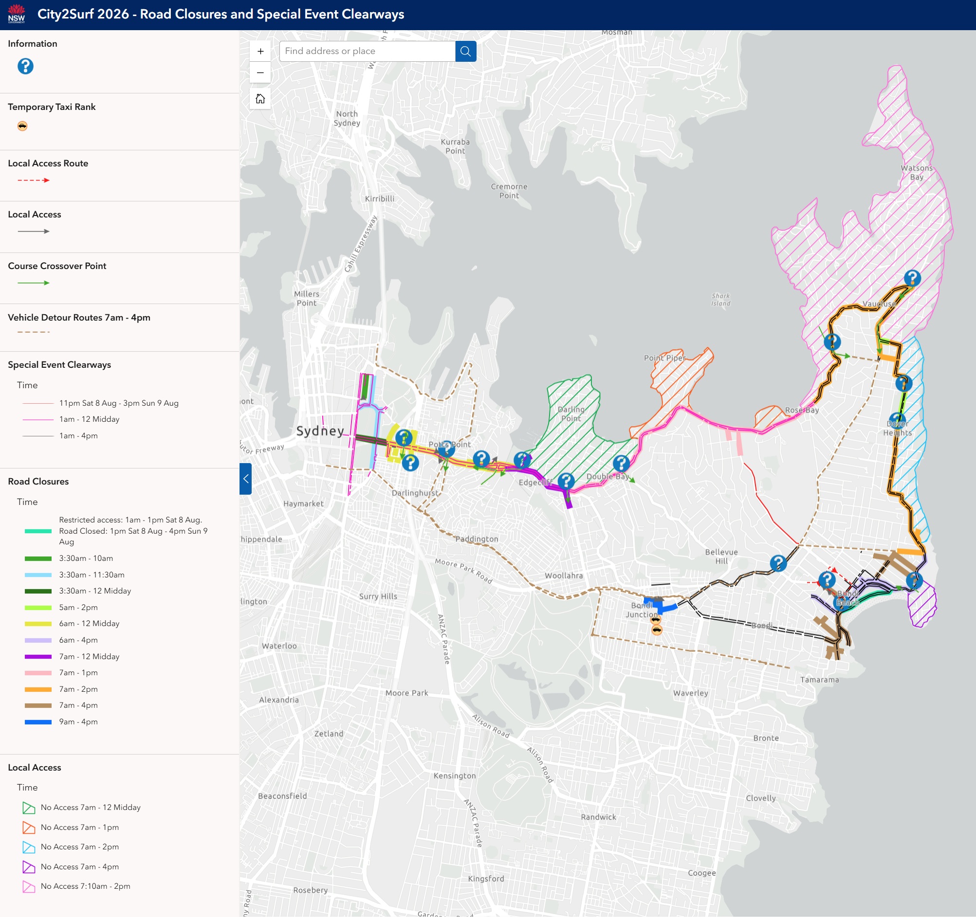
Local access & vehicle crossover points
Crossover points along the course will be maintained for local access until 7am or 7.10am, depending on the location. After these times, there will be no vehicle access permitted while the run is underway and until roads have safely reopened to traffic.
Residents located between the course and the coastline will not be able to enter or exit the area while roads are closed – residents in these locations should relocate their vehicle to the other side of the course before roads close then cross the course by foot prior to the event starting.
Vehicle course crossover points:
- Woolloomooloo/Darlinghurst: Crown Street at William Street is a two-way crossover point until 7:10am.
- Potts Point/Darlinghurst: Victoria Street and Darlinghurst Road are a two-way crossover points open throughout the event.
- Darling Point: Southbound exit only from New Beach Road to Neild Avenue until 7am.
- Double Bay to Edgecliff: Southbound exit only from Ocean Avenue to Ocean Street until 7.10am. No entry after 7am.
- Double Bay to Bellevue Hill: Southbound exit only from Cross Street to Bellevue Road at New South Head Road until 7.10am. No entry after 7am.
- Vaucluse/Rose Bay: Towns Road/Vaucluse Road at New South Head Road is a two-way crossover point until 7.10am.
- Vaucluse/Watsons Bay: Southbound exit only from Old South Head Road at New South Head Road until 7.10am.
- North Bondi/Bondi Beach: One-way exit only from Brighton Boulevard and Ramsgate Avenue at Campbell Parade until 7am. No entry after 6am.
Local access changes
- Bondi Road: Local residents are strongly encouraged to avoid unnecessary travel on Bondi Road – the road will be heavily congested with hundreds of buses transporting thousands of participants between the Beach and the Junction. Residents north of Bondi Road should use Old South Head Road to enter or exit the area via Blair Street. Residents south of Bondi Road should use Birrell Street.
- Bondi Beach: Local access for properties at Bondi Beach will be maintained via one-way traffic only via Curlewis, Gould and Hall streets. Properties between Lamrock Avenue and Hall Street exit onto Hall Street only, no access to or from Lamrock Avenue.
- Dover Heights: Managed access for properties on Military Road between Lancaster Road and Blake Street from 5am to 7am only.
- Cross City Tunnel westbound: Access to the Cross City Tunnel and Craigend Street (westbound direction only) is maintained via McLachlan Avenue at Rushcutters Bay. The tunnel will be closed eastbound until 12pm.
For the latest traffic information visit Live Traffic NSW or download a real-time traffic app from the App Store or Google Play.
Parking
Key roads around the start line will close from as early as 3.30am, and paid parking options in the city are limited on a Sunday morning, so participants are encouraged to catch public transport. Travel on transport is covered by your event registration and there are plenty of frequent transport service options nearby.
If you must drive, remember to allow extra time to walk from your parking space and arrive at the start area at least 30-minutes before your scheduled start time.
Visit Wilson Parking, Secure Parking or City of Sydney websites for car park options. Be mindful of car park opening times and road closures.
Special event clearways
Special event clearway parking restrictions will be in effect on both sides of the entire 14km course to ensure the event is clear of vehicles. Clearways will also be in effect on detour routes and streets surrounding the course.
Check signs carefully on event day and the night before as vehicles left in signposted clearways will be towed and a fee applies. If your vehicle is towed it will be relocated to the nearest available legal parking space.
Saturday 8 August from 11pm:
- Rose Bay: Eastern side of O’Sullivan Road between Latimer Road to Old South Head Road until 3pm Sunday 9 August.
Sunday 9 August from 1am:
- Sydney CBD to Rose Bay – 1am to 12pm: sections of Castlereagh Street, Clarence Street, College Street, Elizabeth Street, Hunter Street, Macquarie Street, Park Street, Phillip Street, Prince Albert Road, St James Road, Wentworth Avenue and other surrounding streets; on sections of local streets in Darlinghurst and on both sides of William Street / New South Head Road from College Street in the city to Dover Road in Rose Bay.
- Rose Bay to North Bondi – 1am to 4pm: on both sides of New South Head Road, Old South Head Road, Military Road.
- Bondi and North Bondi – 1am to 4pm: onboth sides of Campbell Parade, Bondi Road from Old South Head Road to Sandridge Street, Old South Head Road from Syd Einfeld Drive to Blair Street.
- Bondi Beach – 1am to 4pm: both sides of Campbell Parade, Queen Elizabeth Road, Bondi Road, Old South Head Road from Bondi Road to O’Sullivan Road, and on sections of other streets around the beach including Curlewis Street, Gould Street, Hall Street, Lamrock Avenue, Sandridge Street, Wairoa Avenue;
- Bondi Junction – 1am to 4pm: on sections of Oxford Street and Bronte Road; and on a section of Edgecliff Road in Woollarah.
Clearways are strict no-parking zones for all vehicle types and apply even to local residents and TfNSW Mobility Scheme Permit holders. Check signs carefully as vehicles left in clearways will be towed and a fee applies. If your vehicle is towed, you can search your vehicle registration at the Find My Car website to find its new location or alternatively call 132 701 to speak to an operator.
Other sections of the course do not have special event clearways however, if you park on the event route before road closures are in place you will not be able to move your vehicle until roads reopen, unless permitted to do so by a Traffic Controller or NSW Police on-site.
Road closures and clearways maps
- TfNSW Interactive Map
- Overview map (pdf 5.9MB)
- Sydney CBD to Double Bay (pdf 1.0MB)
- Double Bay to Dover Heights (pdf 570KB)
- Dover Heights to Bondi Junction (pdf 1.2MB)
For more details on special event clearway locations and times, visit Live Traffic NSW.
Drop-off in Sydney CBD
The accessible drop off for the Start area is the western side of Phillip Street, between Martin Place and Hunter Street. Phillip Street access is via King Street only. Phillip Street is closed southbound from Hunter Street to create a one-way northbound entry and exit system.
Pick-up from Bondi Beach
The accessible pick-up location is on the southern side of Warners Avenue, between Wairoa Avenue and the mid-block pedestrian crossing behind Bondi Beach Public School. Approach eastbound via Ramsgate Avenue then turn right into Wairoa Avenue and right into Warners Avenue. Participants are asked to be on-site and ready to depart before vehicles approach for pick-up.
Accessible parking
Off-street secure parking with accessible spaces. For more information, visit car park operator websites at Wilson Parking, Secure Parking or City of Sydney.
Transport
Accessible trips are shown in the Trip Planner with the wheelchair icon. You can select "accessible services only" in the Options to ensure you only see accessible services. Only trip plans with accessible train platforms, ferry wharves and buses will be presented. See accessible travel or download a transport app (select the "Accessibility" filter).